TABLE OF CONTENTS
1 INTRODUCTION
2 OBJECTIVES
3 AREA OF INVESTIGATION
4 GEOLOGY / HYDROLOGY OF THE AREA OF INVESTIGATION
5 HYDROGEOLOGY
6 TECHNICAL CONSTRAINTS
7 WATER QUALITY ISSUES
8 PROPOSAL CALL
9 HYDROGEOLOGICAL EXPLORATION PROGRAM
10 CONCLUSIONS & RECOMMENDATIONS
APPENDIX A
AREA 1: MAP 1A- LOCALITY
MAP 1B- GEOLOGY
MAP 1C- BOREHOLE PROSPECTS & HARVEST POTENTIAL
AREA 2: MAP 2A- LOCALITY
MAP 2B- GEOLOGY
MAP 2C- BOREHOLE PROSPECTS & HARVEST POTENTIAL
AREA 3: MAP 3A- LOCALITY
MAP 3B- GEOLOGY
MAP 3C- BOREHOLE PROSPECTS & HARVEST POTENTIAL
APPENDIX B Aquabase borehole database: columnar reports
AREA 1: Site Location and chemistry
Site Location, Geohydrology and Management Recommendations
AREA 2: Site Location and chemistry
Site Location, Geohydrology and Management Recommendations
AREA 3: Site Location and chemistry
Site Location, Geohydrology and Management Recommendations
INTRODUCTION
The already undesirable levels of water supply risk, initiated this study to investigate further options to augment the supply. This report forms part of a feasibility study undertaken by Dynamic Engineering Associates since additional raw water supply sources need to be identified, planned and implemented as soon as possible for the communities.
The purpose of this study was to assess the groundwater potential at a feasibility level as a first phase, and to ensure that all major issues relating to groundwater supply are identified. The results from this study are aimed at enabling recommendations to be made on the development options of future raw water supply sources
OBJECTIVES
A scheme for groundwater development has the following key purposes:
To produce water from a large subterranean reservoir (aquifer) and to demonstrate the economic advantage(s) (if any) of this resource;
To obtain fundamental information about hydrogeological properties and parameters in the aquifer and its interaction with related systems, in preparation for future expansion into a larger scale and wider extent of exploitation;
To set up a coordinated management and monitoring system to address the medium- to long-term uncertainties about sustainability, impact on the environment and existing usage, either surface or groundwater, and the consequent legal and social impacts of groundwater abstraction;
Identify go/no-go criteria for incremental expansion of the scheme.
AREA OF INVESTIGATION
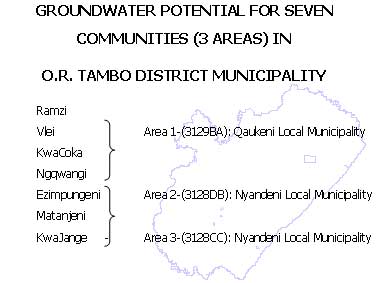
The first area (Area 1) includes the following three communities, Ramzi, Vlei and KwaCoka. The area is located in the eastern region of the Qaukeni Local Municipality. It is situated approximately 25 km to the east of Flagstaff. The map reference for these communities is 3129BA.
The second area (Area 2) consists of the Ngqwangi, Ezimpungeni and Matanjeni communities. They are all situated to the east of Umtata at varying distances from 10 to 20 km. The area is located in the western region of the Nyandeni Local Municipality. (Map reference 3128DB)
The last area (Area 3) is only one community, KwaJange. This community is also located in the Nyandeni Local Municipality in the southern region. The area is located approximately 90 km to the east of Umtata. (Map reference 3128CC)
Refer to Appendix A: Map 1A, 2A and 3A.
Villages are mainly confined to hilltops or moderate slopes.
GEOLOGY / HYDROLOGY OF THE AREA OF INVESTIGATION
The Beaufort and Ecca Groups are the geologically dominant units in the areas. These Groups forms part of the Karoo Sequense. Dolerite intrusions form massive sheets and dyke intrusions in these Groups. The Beaufort Group is divided into two subgroups namely the Tarkastad and Adelaide Subgroups. The Adelaide Subgroup falls into the study area but not the Tarkastad Subgroup.
Mudstone dominates the Adelaide Subgroup, but the Subgroup becomes more sandstone rich in depth. The formation is approximately 2000 m deep. The mudstone is essentially a gray, fine-grained, argillaceous rock type, which is particularly susceptible to erosion when exposed to atmosphere. As a result, the mudstone usually underlies the low-lying topographic areas. This information is also the main source of the deep silt layers found in the valley and also the high silt content of river water.
Dykes are present in the area, the most prominent being the east-west
striking dykes. The presence of the intrusive sills and dykes of
dolerite is clearly evident. The less prominent dykes with varying
orientations are not as obvious and can generally be located by field mapping
aided by remote sensing techniques. Dykes cutting through sills will
be a main target for groundwater exploration.
Localized fracturing associated with dolerite intrusions occur in both
the host rock and the dolerite itself. Lithological boundaries often represent
opportunity when there is local flexure and rock competence contrasts.
(Refer to Appendix A: Map 1B, 2B and 3B)
Area 1 covers 2 quaternary sub-catchments T60C and T60F,
Area 2 falls in T20D and T20E, and
Area 3 in T70F. (Refer to Appendix A: Map 1A, 2A and 3A)
HYDROGEOLOGY
Groundwater occurs mainly in the rock matrix. Principal transmissivity
is derived from large but infrequent fractures. These fractures have a
relatively low storage capacity. Secondary transmissivity occur by numerous
micro fissures with higher storativity but lower transmissivity. Hence
the name dual porosity aquifers. Deeper fractures often have a higher transmissivity
but lower storativity than shallow fractures.
The Groundwater Resources of the Republic of South Africa, Sheet 2,
1995 gives the probability of drilling a successful borehole, yield of
more than 0.1l/s, for the three areas between 40-60%.
For drilling a borehole yielding more than 2l/s: Area 1 - 20-30%
Area 2 - 10-20%
Area 3 - 30-40%
(Refer to Appendix A: Map 1C, 2C and 3C)
The maps were drawn up using previous drilling records in the area
and are therefore not absolute, especially since few records of previous
drilling was available for the area.
From Khulani VSA Groundwater Consultants borehole database, within Area
1 the average discharge rate is 6.7l/s (?blow yield), within a radius of
2 km (from an existing total of 14 boreholes). In Area 2 there are
50 existing boreholes, but information on the boreholes are limited, the
average blow yield within this area are 0.6 l/s. And in Area 3, borehole
information are even more limited, there are 4 existing boreholes with
one blow yield of 0.3 l/s. Existing borehole information on Area
2 & 3 are not representative of the potential of the areas.
(Refer to Appendix B: Aquabase database reports)
TECHNICAL CONSTRAINTS
There are no drilling or pumping technology limitations except for terrain accessibility. Existing technologies of air-percussion and rotary core drilling should suffice. High mobility drilling rigs are of the utmost importance in accessing likely high yielding drilling sites. Any future drilling must take this into account.
It is recommended that geophysical explorations be done on promising
geological sites within all of the communities.
Borehole design considerations dictate that all boreholes be effectively
and permanently cased.
The potential for easy and relatively inexpensive connections to
existing water supply infra-structure may be important considerations in
the selection of the most appropriate target sites.
WATER QUALITY ISSUES
It is possible to reasonably classify the expected groundwater chemistry
in the study area, because of previously taken samples.
In the study area electrical conductivities rarely exceeds the maximum
acceptable limit for human consumption. In general, the water quality
in the areas are of an acceptable quality.
The Department of Water Affairs and Forestry developed a ground water
quality classification system in 1996 in association with the Department
of Health. This classification was revised in 1998, as detailed in the
following document:
The Departments of Water Affairs and Forestry, and Health, and
the Water
Research Commission, 1998.
Quality of domestic water supplies Volume 1: Assessment Guide.
Second Edition.
This system facilitates the evaluation of water based on five water
quality classes with regard to the use of the water for domestic use:
CLASS 0 - Ideal quality water
CLASS I - Good quality water
CLASS II - Marginal quality water
CLASS Ill - Poor quality water
CLASS IV - Dangerous water quality
PROPOSAL CALLError! Bookmark not defined.
A proposal call should invite submissions that should be structured
to permit timeous decisions to be made about incremental exploration and
development in all target areas identified.
The successful drilling of the groundwater resource will require that
a project team of the requisite skills and necessary experience is assembled,
the work packages assigned, project times and dependencies delineated,
and final deliverables agreed by all parties.
The key functions of the proposal call are:
Key team members to define and agree in detail on the scope and scale
of the project with special focus on groundwater exploration and management;
Creation of a master project plan and budget that addresses the essential ingredients for successful long-term large scale implementation and management (or not) of the water
Design of the reporting process (this serves two purposes at this early stage: (i) it captures the critical issues, and (ii) it assists the team to focus on what is absolutely necessary to produce the contractual deliverables).
Allows for review of the budget and planning for the full implementation
of a well field and further studies and development.
HYDROGEOLOGICAL EXPLORATION PROGRAM
Because of the focus of this proposal call on the potential of groundwater
to augment the water supply to the district, more detail is presented below
with respect to the hydrogeological mapping of the area. The main elements
of this program are:
Quantitative mapping of topography and geology;
Geophysical exploration;
Necessary project contract documentation (e.g., land access, drilling
tenders and other subcontracted work);
Design and management protocols for exploration drilling, testing
for multiple purposes, monitoring and sampling.
Drilling and testing and sampling of prioritised sites;
Mapping of the lithological and hydro chemical relationships in the
aquifer;
Mapping and, so far as possible, quantification of the relationship between groundwater and the lithology;
Optimisation of borehole design and costing with regard to anticipated
yield.
Management recommendations.
The topographic and geological mapping function is preferably and most
economically carried out over the whole area, incorporating all potential
target zones. It is important from the outset to develop a clear regional
perspective and an accurate knowledge of the wider system boundary conditions;
this purpose is best achieved by covering all of the prospective areas
in a first phase.
The hydrogeological exploration program should also include a detailed
survey of all the existing boreholes over the whole area and the sampling
of these and selected surface-water and spring systems.
CONCLUSIONS & RECOMMENDATIONS
The main conclusions are summarized below.
The groundwater potential varies from moderate to good for the above
metioned villages (hydrocensus to geological considerations)
The financial component of the groundwater feasibility investigation is excellent due to:
o Subsidized drilling program through Khulani VSA. Khulani VSA
have a MOU with Aboutlife (NGO). Three drilling rigs are available.
o Subsidized test pumping of existing boreholes
o Free installation of roundabout pumps on low yielding boreholes
Seven communities covering an area of approximately 70 km2, covering
5 quaternary sub-catchments within the T60, T20 and T70 tertiary catchments,
is designated for further groundwater-directed investigation.
The choice of area and site for the groundwater supply schemes is
governed not only by scientific and topographical considerations, but also
by the need to optimise the integration of groundwater supply with the
existing water infrastructure, i.e., to obtain the most information at
the least capital cost and risk.
It is recommended that geophysical exploration be done on the most
promising geological structures, to obtain the best results.
There are no drilling or pumping technology limitations except for
terrain accessibility. Existing technologies of air-percussion and rotary
core drilling should suffice.
In the study area electrical conductivities (ECs) rarely exceeds
the maximum acceptable limit for human consumption, but the iron content
within the area could cause a problem. In general, the water quality
in the district is of an acceptable quality.
It is recommended that the boreholes be pumped at lower rates continuously
such that the water table is not drawn down below the level of the first
water strike. This is to avoid the water being oxygenated as it repeatedly
cascades down in the borehole on a daily basis when the pumps are switched
off/on after a pump/recovery cycle.
Borehole monitoring and preventative maintenance is mandatory to,
so far as possible, avoid or limit the need for well rehabilitation.
APPENDIX A
AREA 1: MAP 1A- LOCALITY
MAP 1B- GEOLOGY
MAP 1C- BOREHOLE PROSPECTS & HARVEST POTENTIAL
AREA 2: MAP 2A- LOCALITY
MAP 2B- GEOLOGY
MAP 2C- BOREHOLE PROSPECTS & HARVEST POTENTIAL
AREA 3: MAP 3A- LOCALITY
MAP 3B- GEOLOGY
MAP 3C- BOREHOLE PROSPECTS & HARVEST POTENTIAL
APPENDIX B
Aquabase borehole database: columnar reports
AREA 1: Site Location and chemistry
Site Location, Geohydrology and Management Recommendations
AREA 2: Site Location and chemistry
Site Location, Geohydrology and Management Recommendations
AREA 3: Site Location and chemistry
Site Location, Geohydrology and Management Recommendations
QUOTATION FOR BOREHOLE ENTIAL FOR SEVEN COMMUNITIES
ummation of the communities:
| Area | Community Name | Population | Demand (l/s) (12 hours) | Required Blow yield (l/s) | Proposed amount of boreholes to be drilled | Proposed geophysical traverses |
| 1 | 1 Ramzi | 3874 | 2.24 | 6.7 | 4 | 4 |
| 1 | 2 Vlei | 3923 | 2.28 | 6.8 | 4 | 4 |
| 1 | 3 KwaCoka | 4123 | 2.36 | 7.0 | 4 | 4 |
| 2 | 4 Ngqwangi | 2322 | 1.40 | 4.2 | 3 | 3 |
| 2 | 5 Ezimpungeni | 1445 | 0.84 | 2.5 | 2 | 2 |
| 2 | 6 Matanjeni | 921 | 0.54 | 1.6 | 2 | 2 |
| 3 | 7 KwaJange | ? | ? | ? | 2 | 2 |
| Totals | 28,8 | 22 | 22 |
This is the recommended total boreholes to be drilled that will satisfy
a demand of 25 liters per person per day. If it is not necessary
to satisfy this demand (due to the scope of work), or due to budget constraints,
changes can be made to the total number of boreholes that should be drilled.
Proposed Cost Breakdown:
Summary of Costs
Geohydrological fees Contractor fees
| Actions | Units | Fees | Disburse-ments | Unit cost | Total cost | Unit cost | Total cost |
| Liaison | 22 bh* | 10,620 | 500 | 505 | 11,120 | ||
| Siting | 22 bh | 37,850 | 20,614 | 2,657 | 58,464 | ||
| Drilling supervision | 22 bh | 25,550 | 15,094 | 1,847 | 40,644 | 22,232 | 489,110 |
| Testing supervision | 14 bh | 9,015 | 8,995 | 1,286 | 18,010 | 9,345 | 130,835 |
| Reporting | Project | 23,334 | 23,334 | 23,334 | |||
| 151,572 | 619,945 |
The Geohydrological Consultants fee for drilling 1 borehole will be
R 6 889, this includes the liaison (including a 2 day hydro-census), geophysical
siting, drilling supervision, testing supervision and report writing.
Drilling of the boreholes will be approximately R 22 232 per borehole and
the pump testing of the borehole R 9 345. The total number of boreholes
can be changed according to the scope of the work/ budget constraints.
For this quotation an assumption has been made that only 14 boreholes
will be successful (Refer to the Geohydrological Report for the proposal
call for the Feasibility Study and Pilot Project on the Groundwater Potential).
Additional to this quotation, will be the chemical sample analyses and
the installation of pump equipments.
a) Roundabout hand pumps can be installed on low yielding (< 0.25l/s
blow yield) boreholes, at no cost (15 are subsidized by Aboutlife? - value
±R35 000).
b) Afridev hand pumps can be installed at cost (±R6 500). (Boreholes
yielding from 0.25 1.0l/s) (Subsidized by Aboutlife).
c) It is recommended to install a submersible or mono type pump on
boreholes yielding higher than 1.0l/s. This will ensure the use of
the borehole to its full capacity. Cost will vary accordingly to
the type of pump that will be installed.
d) One chemical analyses will be taken per borehole during pump testing.
The costs for the analyses are not included and will be in the order of
R 500.00 per sample.
Regards,
Eunice Goossens (Geohydrologist)